

Species profile—Grevillea venusta (grevillea)
Classification
Plantae (plants) → Equisetopsida (land plants) → Proteaceae → Grevillea venusta (grevillea)
Sighting data
Species details
- Kingdom
- Plantae (plants)
- Class
- Equisetopsida (land plants)
- Family
- Proteaceae
- Scientific name
- Grevillea venusta R.Br.
- Common name
- grevillea
- WildNet taxon ID
- 13207
- Nature Conservation Act 1992 (NCA) status
- Vulnerable
- Conservation significant
- Yes
- Confidential
- No
- Endemicity
- Native
- Pest status
- Nil
- Description
- Grevillea venusta is an erect shrub growing 2 to 5 m tall. The leaves are 3.5 to 19 cm long, 5 to 30 mm wide, entire, narrowly elliptic to narrowly ovate, and/or 2 to 7 partite with narrowly oblong to narrowly elliptic ascending lobes. The lowermost lobes are 4 to 11 cm long and 6 to 16 mm wide. The leaf margins are flat or slightly recurved. The lower leaf surface is sparsely to densely sericeous. The conflorescence is terminal, erect, simple or basally 2-branched. The unit conflorescence is subcylindrical or a loose cluster, subsynchronous or weakly acropetal. The ultimate floral rachis is 50 to 90 mm long. The perianth is a rich green colour in the basal half and yellow to orange above. The style is a deep maroon to purplish black colour, with conspicuous white hairs and a maroon tip. The perianth is loosely to sparsely sericeous outside, pilose inside. The pistil is 30 to 36 mm long. The stipe is 8.2 to 9.2 mm long. The fruits are dry, 16 to 19 mm long (Makinson, 2000).
G. venusta differs from G. glossadenia in its arcuate, inconspicuous nectary, usually 10 to 20 flowers per conflorescence and its paler style hairs (Makinson, 2000). - Map
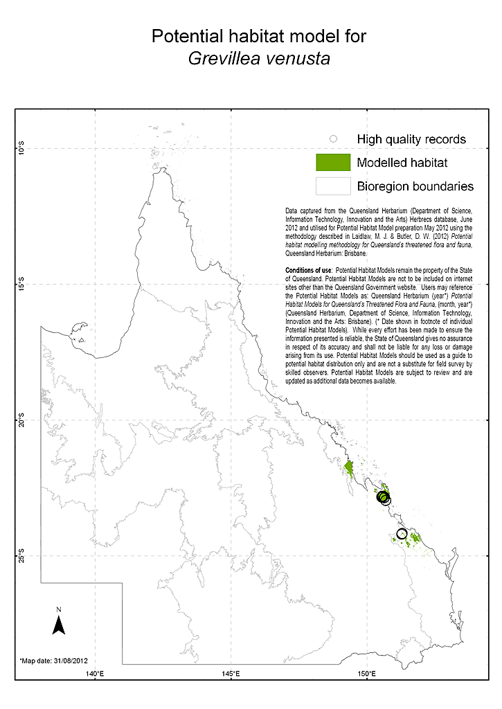
- View Map
- Distribution
- Grevillea venusta is known from central eastern Queensland, where it occurs in coastal areas from Many Peaks Range to Shoalwater Bay (Makinson, 2000). This species has been described as locally common at Oxley Creek in Many Peaks Range; locally common at a tributary of Werribee Creek, 1.5 km west-south-west of Mount Carroll in the Shoalwater Bay area; very common 2.5 km north of Mount Parnassus; and 10 plants were seen at the base of Mount Parnassus (BRI collection records, n.d.).
Grevillea venusta occurs in Castle Tower National Park (Briggs and Leigh, 1996), Shoalwater Bay Military Training Area, Bowenia State Forest (BRI collection records, n.d.), and Byfield State Forest (Queensland Herbarium, 2012). - Distributional limits
- -22.7936111, 150.5347834
-27.5391695, 153.047675 - Range derivation
- Range derived from extent of the taxon's verified records
- Habitat
- Grevillea venusta has been collected in rocky areas at the base of mountains, often along creeks in sandy soil, and on granite in sclerophyll forest and woodland. Associated vegetation descriptions include: skeletal sandy soil on rock outcrops; granite with Eucalyptus acmenoides, Corymbia trachyphloia, E. exserta tall open forest with a very sparse upper mid stratum, a mid-dense lower mid stratum of Acacia aulacocarpa and a sparse diverse ground stratum dominated by Xanthorrhoea sp.; and shallow rocky soil with granite, in open forest of Corymbia intermedia, Syncarpia glomulifera and E. acmenoides, with dense low shrub as ground layer (Queensland Herbarium, 2012).
This species occurs within the Fitzroy (Queensland) Natural Resource Management Region. - Reproduction
- Flowering occurs in April, and June to September (Makinson, 2000; Queensland Herbarium, 2012).
- Threatening processes
- The main identified threats to G. venusta are broad-scale vegetation clearing; altered fire regimes; grazing pressure; increasing fragmentation ; and inappropriate forest operations (DSEWPC, 2012).
- Status notes
- Grevillea venusta is listed as Vulnerable under the Queensland Nature Conservation Act 1992
- Management recommendations
- Regional and local priority actions to support the recovery of Grevillea venusta are outlined by DSEWPC (2012). A summary of these include: avoid habitat loss, disturbance and modification (e.g. monitor known populations to identify key threats, minimise adverse impacts from land use at known sites; identify populations of high conservation priority); increase conservation information (raise awareness of Grevillea venusta in the local community); minimise trampling, browsing and grazing (e.g. develop and implement a stock management plan for roadside verges, prevent grazing pressure at known sites through exclusion fencing or other barriers); manage fire (e.g. develop and implement a suitable fire management strategy for G. venusta); and enable recovery of additional sites and/or populations (e.g. undertake appropriate seed collection and storage).
- Notes
- Occurs in the following Queensland pastoral district: Port Curtis. The species was previously listed as vulnerable under the EPBC Act 1999.
- References
- Department of Sustainability, Environment, Water, Population and Communities (DSEWPC) (2012). Grevillea venusta in Species Profile and Threats Database, Department of Sustainability, Environment, Water, Population and Communities, Canberra. Accessed 17/04/2012. http://www.environment.gov.au/sprat.
Makinson, R.O. in Wilson, A.J.G. (Ed) (2000). Flora of Australia 17A: 115-116.
Queensland Herbarium (2012). Specimen label information. Queensland Herbarium. Accessed 17/04/2012. - Profile author
- Lynise Wearne (17/04/2012)
Other resources
 - Saul, M.,Queensland Herbarium, DES (Licence: CC BY NC)")
Data source
This profile data is sourced from the QLD Wildlife Data API using the Get species by ID function used under CC-By 4.0.
https://apps.des.qld.gov.au/species/?op=getspeciesbyid&taxonid=13207.
This information is sourced from the WildNet database managed by the Queensland Department of Environment and Science.
